Projects
Projects

Structural Assessment
Advanced structural assessment using high resolution imaging and thermal mapping for critical infrastructure.

Agriculture
The use of drone technology sprays crops efficiently and precisely. By flying over the fields, the drone applies fertilizers or pesticides evenly, reducing waste and minimizing soil compaction compared to traditional equipment. It helps farmers save time, lower costs, and protect the environment while improving crop health and yield through targeted application.


SAR
Thermal imaging can be used to assist search and rescue based on their heat signatures, even in darkness or challenging terrain. By capturing clear contrast between warm bodies and cooler surroundings, this technology supports search‑and‑rescue teams, wildlife officials, and security operations. It allows responders to quickly locate individuals who may be lost, hidden, or difficult to see with the naked eye, improving safety and response efficiency.
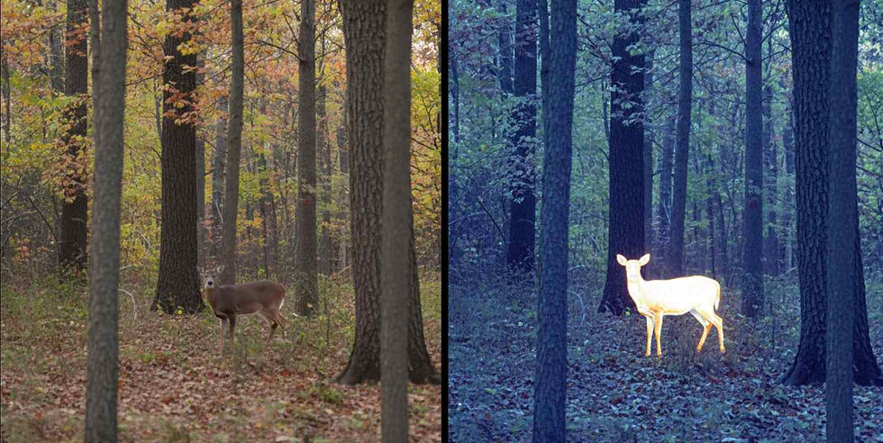
Wildlife
This showcases how advanced imaging helps hunters and wildlife officials identify animals in dense forest environments. By comparing natural daylight visibility with enhanced detection, it demonstrates how technology can reveal wildlife that would otherwise blend into the surroundings. This improves safety, supports responsible wildlife management, and helps officials track animals more accurately in challenging terrain.

Forest Fire fighting
Aerial imaging helps identify lingering hotspots during or after a forest fire. By highlighting areas of active heat that may not be visible to the naked eye, this technology supports firefighters and forestry officials in monitoring fire spread, locating dangerous flare‑ups, and directing resources more effectively. It improves safety, speeds up response efforts, and provides critical insight for managing wildfire conditions in challenging terrain.
Crop Quality
Digital imaging can be used to assess crop quality by analyzing patterns and variations in plant health. By visualizing data in different color formats, farmers and agronomists can quickly identify stressed areas, nutrient deficiencies, or irregular growth that may not be visible through traditional field inspection. This technology supports more accurate decision‑making, improves crop management, and helps optimize yield by highlighting exactly where attention is needed across the field.
